List of projects
Here is a list of projects that I have worked on with some of them shown in more details in the links below:

Here is a list of projects that I have worked on with some of them shown in more details in the links below:
Quantifying and visualizing the changes of iceberg distribution in fjords around the Greenland Ice Sheet.
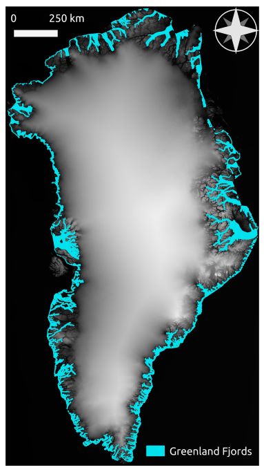
We show that the preponderance of small icebergs results in high freshwater delivery, as well as a short life span of icebergs in fjords. 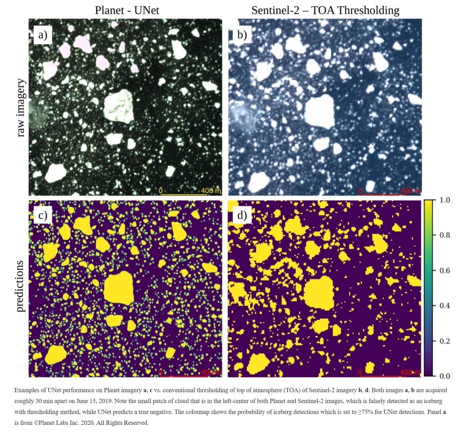
The goal of this project is to analyze iceberg distribution in Sermilik Fjord, South East Greenland. Through this project I want to understand, how the calving processes are impacting Sermilik Fjord (one of the fastest moving glaciers in Greenland) using iceberg distribution. In order to improve the understanding, I will need to perform the following tasks: Visualize iceberg distribution. Determine the frequency size distribution of icebergs in Sermilik Fjord. Calculate percentage ice-cover within 2km x 2km grid cells in Sermilik Fjord. 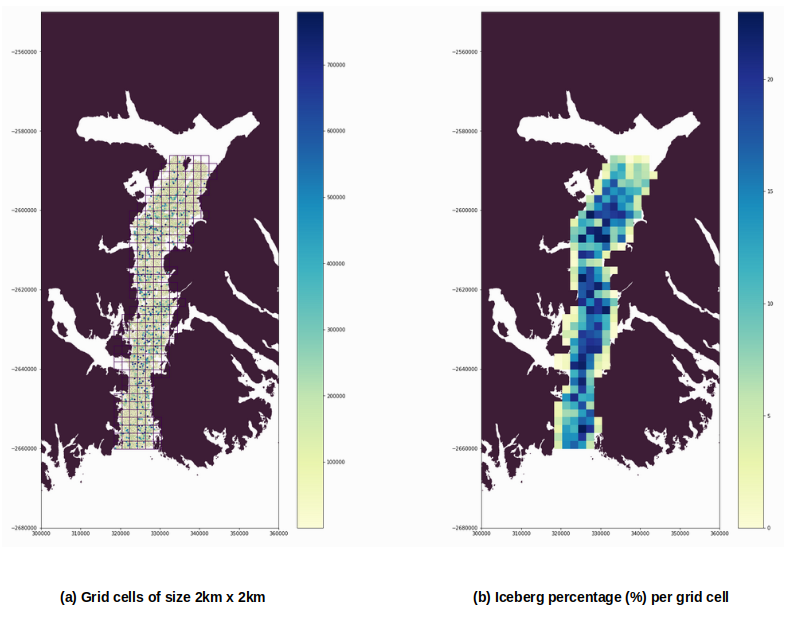
We track glacier terminus position using machine learning with Sentinel-1 SAR imagery.
Using melt estimates from iceberg distribution, surface runoff, and terrestrial runoff we estimate the freshwater flux around Greenland Ice Sheet.
Published in GIS Day@ KU Planning Committee, 2015
Icebergs are an important part of Earth’s freshwater cycle, affecting fjord circulation, marine biology, and nutrient flux. However, very little is known about iceberg distribution patterns, especially how iceberg sizes vary from glacier termini to the open ocean. Such information is critical for freshwater budgets and ocean circulation models. In this study, we quantify iceberg size and distribution in Rink Fjord, West Greenland during the summer of 2015. We show how the iceberg distribution changes throughout the summer season using Landsat 8, panchromatic images at 15 m resolution. The project algorithm runs on QGIS, ArcGIS, Python 2.7, and GDAL. We are working to automate the process so we can expand the study both spatially and temporally. The resulting dataset will help in understanding calving dynamics of different marine terminating glaciers and provide critical information for ocean and fjord models.
Recommended citation: Shankar, S., Stearns, L. A. (2015). "Quantifying Iceberg Distribution in Rink Fjord using Satellite Remote Sensing" GIS Day@ KU Planning Committee. https://kuscholarworks.ku.edu/bitstream/handle/1808/20364/gis_day2015_student_shankar.pdf?sequence=1
Published in American Geophysical Union, Ocean Sciences Meeting 2016, 2016
Icebergs are an integral part of the climate system as they interact with the ocean, atmosphere and cryosphere. Most importantly, icebergs transport a substantial amount of fresh water away from the margins of the ice sheets and into the ocean, impacting sea ice formation, fjord circulation, and nutrient fluxes. To date, only a handful of studies quantify iceberg size distribution in the Arctic, and none do so on temporal scales that capture the physical processes of calving dynamics and fjord circulation. We use a combination of radar and optical imagery to quantify iceberg distribution in Uummannaq Bay, West Greenland. We also estimate the calving rate of glaciers in the region, to better understand calving style on a seasonal basis. The results are used to estimate the contribution of solid ice to the oceans from each glacier in the region, understand the calving style of glaciers in our region, and quantify temporal patterns in iceberg distribution.
Recommended citation: Stearns, L. A.; Shankar, S.; Byers, L. C.; Sutherland, D.; Shroyer, E.; Nash, J. D.; Catania, G. A.; van der Veen, C. J. (2016). "Quantification of calving rates and iceberg size distribution in West Greenland" American Geophysical Union, Ocean Sciences Meeting 2016. https://ui.adsabs.harvard.edu/abs/2016AGUOSHE52A..04S/abstract
Published in GIS Day@ KU Planning Committee, 2016
The rate of iceberg production is largely modulated by ice sheet dynamics, and the rate at which they melt can in luence jord circulation. As a result, when climate models do not include variable iceberg properties, they poorly constrain the atmosphere-ice sheet-ocean relationship.
Recommended citation: Shankar, S., Stearns, L. A.(2016). "Quantification and Analysis of Icebergs Distribution around Greenland using Sentinel SAR images" GIS Day@ KU Planning Committee https://kuscholarworks.ku.edu/bitstream/handle/1808/23352/gis_day2016student_shankar.pdf?sequence=1
Published in American Geophysical Union, 2017
Teaching about climate and climate change is conceptually challenging. While teaching tools and lesson plans are rapidly evolving to help teachers and students improve their understanding of climate processes, there are very few tools targeting ice sheet and glacier dynamics. We have built an interactive ice sheet model that allows students to explore how Antarctic glaciers respond to different climate perturbations. Interactive models offer advantages that are hard to obtain in traditional classroom settings; users can systematically investigate hypothetical situations, explore the effects of modifying systems, and repeatedly observe how systems interrelate. As a result, this project provides a much-needed bridge between the data and models used by the scientific community and students in high school and college.
Recommended citation: Stearns, L. A., Rezvanbehbahani, S., Shankar, S.(2017). "Interactive Ice Sheet Flowline Model for High School and College Students" American Geophysical Union. https://ui.adsabs.harvard.edu/abs/2017AGUFMED31B0283S/abstract
Published in American Geophysical Union, 2017
The advent of remote sensing has greatly facilitated studying the distribution of icebergs. Since icebergs appear in a variety of shapes and sizes in polar regions, investigating their distribution requires robust automated tools.
Recommended citation: Shankar, S., Stearns, L. A., (2017). "Iceberg distribution around the Greenland Ice Sheet from Sentinel-1 imagery https://ui.adsabs.harvard.edu/abs/2017AGUFM.C23B1222S/abstract
Published in American Geophysical Union, 2017
Iceberg calving is an important mechanism of mass loss for the Greenland Ice Sheet, and a key source of freshwater in Greenland fjords. However, the glacier terminus often serves as the discipline boundary between glaciologists and oceanographers, limiting our understanding of how calving behavior (size, location, and timing of calving events) and iceberg distributions in fjords are connected. For example, the size of icebergs that break off glacier termini are dictated by geometry, ice velocity, submarine melt rates, and buoyancy conditions. Iceberg size also dictates freshwater contribution, potentially impacting fjord circulation and sea ice formation. Here, we present an analysis of calving behavior and iceberg distribution for a select number of glacier-fjord systems in Greenland. We use an iterative CFAR (Constant False Alarm Rate) algorithm to automatically detect terminus boundaries and icebergs using Sentinel-1 imagery (from 2015 to present). The high temporal (12-day repeat) and spatial (10 m) resolution Sentinel-1 imagery, combined with publicly available ice velocity data (roughly every 16-days), allows us to simultaneously assess calving behavior and iceberg distribution. Where data are available, we extend our records back in time to investigate long-term controls on calving behavior. The results are used to estimate the contribution of solid ice to the oceans for select glaciers, understand the calving style of these glaciers, and quantify temporal patterns of iceberg distribution.
Recommended citation: Stearns, L. A.; Shankar, S.; van der Veen, C. J.; Rezvanbehbahani, S.; Sutherland, D.; Catania, G. A.; Straneo, F.(2017). "Linking Calving Behavior and Iceberg Distributions in Greenland Fjords" American Geophysical Union. https://ui.adsabs.harvard.edu/abs/2017AGUFM.C12A..03S/abstract
Published in INTERNATIONAL GLACIOLOGICAL SOCIETY : International Symposium on Timescales, Processes and Glacier Dynamics, 2018
Recommended citation: Shankar, S., Stearns, L. A. (2018). "Seasonal variability of Greenland icebergs and calving behavior" International Symposium on Timescales, Processes and Glacier Dynamics.
Published in Joint 53rd South-Central/53rd North-Central/71st Rocky Mtn Section Meeting-2019, 2019
Recommended citation: Brookfield, A.E., Hill, M.C., Rodell, M., Loomis, B., Stotler, R.L., Porter, M.E., Bohling, G.C., Shankar, S., Stearns, L.A. and Smith, J.J.,(2019). "USING IN-SITU AND SATELLITE-BASED OBSERVATIONS TO STUDY THE HIGH PLAINS AQUIFER IN KANSAS" Joint 53rd South-Central/53rd North-Central/71st Rocky Mtn Section Meeting-2019. GSA.
Published in American Geophysical Union, 2019
The advent of remote sensing has greatly facilitated studying the distribution of icebergs. Since icebergs appear in a variety of shapes and sizes in polar regions, investigating their distribution requires robust automated tools.
Recommended citation: Rezvanbehbahani, S., Stearns, L. A., Keramati, R., Shankar, S.(2019). "Automating iceberg detection in Greenland using deep learning on high to moderate-resolution optical imagery" American Geophysical Union. https://ui.adsabs.harvard.edu/abs/2019AGUFM.C31A1490R/abstract
Published in American Geophysical Union, 2019
Time-series of iceberg distribution around Greenland are important for parameterizing calving processes, quantifying freshwater flux, and incorporating into coupled ice-ocean models. However, the size and frequency of icebergs around Greenland are largely unknown. Here we present results from our automated iceberg tracking algorithm, which classifies icebergs around Greenland every 2 weeks from 2016 to 2018. We use predominantly high-resolution IW Sentinel-1 SAR imagery and a combination of detection algorithms to characterize icebergs in open water, sea-ice and pro glacial mélange. Our algorithm first uses Random Forest (RF) supervised classification to mask out the various types of background (open water, sea ice, or proglacial mélange), isolating potential iceberg pixels. A modified Constant False Alarm algorithm further identifies iceberg boundaries.
Recommended citation: Stearns, L. A., Shankar, S.(2019). "Automated iceberg detection around the Greenland Ice Sheet: bimonthly results from 2016 to 2018" American Geophysical Union. https://ui.adsabs.harvard.edu/abs/2019AGUFM.C31A1489S/abstract
Published in NASA PARCA, 2020
Recommended citation: Rezvanbehbahani, S., Stearns, L. A., Shankar, S., & van der Veen, C. J.(2020) "Spatio-temporal changes in freshwater budget in Sermilik fjord from high resolution imagery," NASA PARCA 2020
Published in Nature Communications earth & environment, 2020
Significant portion of icebergs in fjords are comprised of small icebergs that were not detected in previously-available coarser resolution satellite images
Recommended citation: Rezvanbehbahani, S., Stearns, L. A., Keramati, R., Shankar, S., & van der Veen, C. J. (2020). "Significant contribution of small icebergs to the freshwater budget in Greenland fjords." Nature Communications earth & environment, 1(1), 1-7.; Nature Communications earth & environment. 1(1). https://www.nature.com/articles/s43247-020-00032-3
Published in American Geophysical Union, 2020
Our automatic iceberg distribution algorithm and sea-ice classification algorithm relies on Sentinel-1 SAR imagery with IW and EW swaths, at 10 m and 40 m pixel spacing. The freshwater estimates include iceberg melt arising from wave erosion, turbulent water motion, convection, wind driven melt, and solar radiation.
Recommended citation: Shankar, Siddharth, and Leigh A. Stearns.(2020) "Bi-monthly iceberg and sea-ice distributions used to estimate freshwater flux in Southeast Greenland fjords" American Geophysical Union. https://agu.confex.com/agu/fm20/meetingapp.cgi/Paper/766058
Published in ArcticNet 2020 Virtual Arctic Change conference, 2020
The outlet glaciers due to their interaction with ocean water experience sporadic changes at the terminus, which is an important predictive measure for understanding the longevity of their retreat. In this study, we present a tool that automatically identifies the changes in the terminus positions of 239 Greenland glaciers bi-weekly from 2017 to 2019.
Recommended citation: Shankar, S., Stearns, L. A.,Rezvanbehbahani, S.,(2020). "Automated terminus detection of Greenland glaciers using the Width Averaging Terminus Tracking (WATT) tool" ArcticNet 2020 Virtual Arctic Change conference.
Published in American Geophysical Union, 2020
The presence of proglacial mélange adjacent to marine terminating outlet glaciers is thought to play a significant role on calving behavior and glacier stability by exerting a buttressing effect on the calving face.
Recommended citation: Stearns, L. A., Shankar, S., Shahin, M. G., Rezvanbehbahani, S., & van der Veen, C. J. (2020). "Mélange variability around Greenland yields insights into calving dynamics and conditions that favor mélange formation" American Geophysical Union. https://agu.confex.com/agu/fm20/meetingapp.cgi/Paper/733458
Published:
This is a description of your talk, which is a markdown files that can be all markdown-ified like any other post. Yay markdown!
Published:
This is a description of your conference proceedings talk, note the different field in type. You can put anything in this field.
Undergraduate course, University 1, Department, 2014
This is a description of a teaching experience. You can use markdown like any other post.
Workshop, University 1, Department, 2015
This is a description of a teaching experience. You can use markdown like any other post.